What is it about the old Vanderbilt/Motor Parkway that intrigues so many folks today? Maybe it’s the fact that very few roads – especially highways or parkways – are built in this country and then allowed to deteriorate or be closed and dismantled. Although the Vanderbilt parkway was a private undertaking it was a public road and its fate somewhat unique.
William K. Vanderbilt, great grandson of the railroad magnate Cornelius Vanderbilt, had raced cars in Europe. He was determined to bring auto racing to the U.S. to spur the fledgling automotive industry in America so he sponsored a Vanderbilt Cup race, the first in 1904. He laid out a course using public roads but, after several years and some deaths of spectators straying too close to the speeding cars, he presented his idea for a separate Long Island Motor Parkway. It was begun in 1908 and completed in 1909. Ordinary motorists could drive the toll road when it wasn’t being used for racing.
After only a couple of years of auto races, the state legislature passed a law forbidding racing on public roads. As more free roads were built on Long Island, the Vanderbilt – a toll road – became less-traveled and ceased to earn its keep. Much of the parkway was sold to the State Park Commission in 1938 to use as they saw fit; some sections are currently used as the right-of-way for tall towers holding electrical power lines.
When I was growing up in central Queens County during the ‘50s and ‘60s, I often heard people speak of the Motor Parkway or Vanderbilt Parkway. I remember seeing some remnants of the old road when I rode my bike to nearby Cunningham and Alley Pond Parks as a teenager. My friend, Bill, who I worked with for several years, tells me he would get on it with his bike during the ‘50s, at about 73rd Avenue and Francis Lewis Blvd., in what is now the Fresh Meadows area. “There was a steep downhill grade from Springfield Blvd., east through Alley Pond Park, that was great for coasting, ending around what is now the Cross Island Parkway near Creedmore State Hospital,” Bill remembers.

I have found, using several old and new maps (including this one above), the Vanderbilt Motor Parkway had its start in the vicinity of Nassau Road, (Horace Harding Blvd. – today’s Long Island Expressway), in between a spur of the North Hempstead Turnpike (today’s Booth Memorial Avenue) and Queens Avenue (today’s 46th Avenue/ Hollis Court Blvd.) It then followed, pretty closely, the west side of Francis Lewis Boulevard, curved east through Cunningham and Alley Pond Parks (north of today’s Union Turnpike), then ran closely parallel to today’s Grand Central/Northern State Parkway through western Nassau County before it dipped further south and east.
(Click on each map to enlarge it.)
In Suffolk County today, major portions of the Motor Parkway (widened
and resurfaced, of course) crisscross the LIE around the Hauppauge area.
There are some less-obvious but noteworthy items to check out on these maps. North Hempstead Turnpike was originally North Country Road, an old Indian path, much-used by early settlers on the north shore of the Island. Today we know it as Northern Boulevard or route 25A; but look at it’s number designation in 1927 – it’s route 25! Today that number is given to Jericho Turnpike – but on this map, Jericho is designated 25A! On the south shore, there’s a familiar route number: 27, which many of today’s drivers recognize as Sunrise Highway. But the route 27 on this map is actually Merrick Road; today, Merrick Road/Montauk Highway is 27A and Sunrise Highway is 27.
(On this black and white version of the map, below,
the Vanderbilt/Motor Parkway is highlighted in yellow.
Click on the map to enlarge it.))
(Newer roads have been drawn into this old map, below:
the Long Island Expressway (route 495) is highlighted in pink,
the Vanderbilt Parkway in yellow, and
the Meadowbrook State Parkway, completed in 1956, in blue.)
Walking or biking on the western section today feels eerie; almost like finding an ancient, medieval trail lost in the forest. In the area between what is today the Cross Island Parkway and Clearview Expressway, the Motor Parkway rode the crest of one of the highest plateaus on Long Island, affording a great view toward the south shore; drivers on the Grand Central Parkway can catch that view today if they’re careful.
One interesting fact for me is that the first stretch of the Motor Parkway was reportedly built from Westbury to Bethpage, just a half-mile north of where I currently live in East Meadow. At the time, it began around today’s Merrick Avenue, near the entrance to Eisenhower Park, exited that piece of land and ran south-east on what is today Salisbury Park Drive, bordering the park’s golf course, before crossing what is today Carman Avenue and what was then Newbridge Avenue (today, Newbridge Road/route 106), before continuing east.
(Click on any photo to enlarge it.)
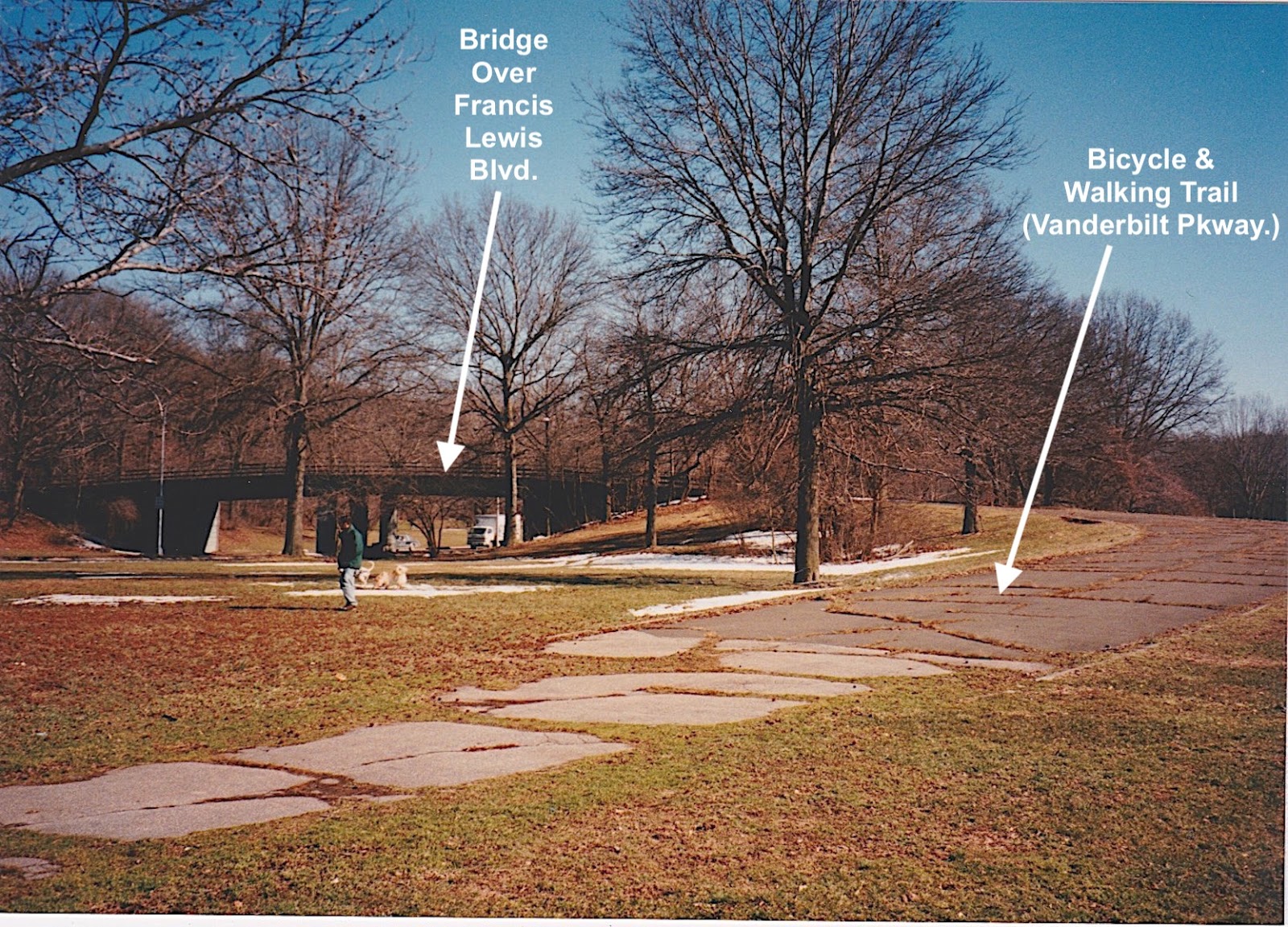
Current view looking east from Carman Avenue, as it
crosses Newbridge Road; the tall towers with power lines
continue east on the old right-of-way of the Motor Parkway.
Much has been written about the Vanderbilt Parkway by now but, on a balmy Tuesday, March 12, 1996, I set out to look for some remnants of the old road (some newer photos have been added since that initial trip). Armed with my old maps and a Pentax camera, I photographed the areas closest to my immediate vicinity of East Meadow. Driving west, the next stop was Garden City.
One of the original Vanderbilt Parkway toll houses had been moved to a spot on 7th Street to be used as the Garden City Chamber of Commerce headquarters in 1989. The toll house originally stood on a spot just north of Stewart Avenue and east of Clinton Road (just west of today's Roosevelt Field Shopping Mall); on the same site was the parkway’s headquarters building which no longer exists.
Toll house now serving as the
Garden City Chamber Of Commerce headquarters.
Near where the toll house once stood a little dead-end street called Vanderbilt Place now holds a few homes. Just to its north, you can still find the concrete embankment of a bridge that once crossed over Clinton Road, one of 65 such structures along the Vanderbilt Parkway’s 48 miles. The surface of the road was innovative for its time: two layers of crushed stone held a wire mesh between them, thin concrete was poured throughout and a final layer floated on top and brushed to provide a rough surface. Part of this original pavement can be found at the Clinton Road site.
After the parkway crossed Clinton Road, traveling west, it curved north and ran a couple of miles before entering what is today the Wheatly Hills Golf Course. This entire section is now the cleared greenbelt of power lines and their giant mesh frame towers. At many of the places that local roads now cross or traverse this stretch, you can find traces of the old road.
On the north side of Westbury Avenue, just west of
Glen Cove Road, in south Mineola, you can see the route
of the old Motor Parkway between people's back yards.
As the parkway continued west, it meandered through central Nassau County, a densely populated area which, today, hides most traces of the former road. One obvious exception is an old stone bridge on Old Court House Road, built in 1909 over what was once Motor Parkway beneath it – accessible off Executive Drive in the Manhasset Hills area.
Under the old bridge at Old Court House Road.
Old Court House Road as it crossed the old bridge.
I next decided to drive to the western-most end of the old parkway for I knew that some of the road still existed in the area of Cunningham Park. I was surprised to find much more than I’d expected. Traveling north on 199th Street, just to the west of Francis Lewis Boulevard, I saw a large grassy area on the right, used as a recreation area by the local residents. And then...there it was! My first encounter with a part of the old parkway still in use. An embankment of earth held a ten-foot wide piece of pavement as it curved around and over Francis Lewis Blvd. on a new bridge that obviously replaces an older one from the early days.
The bridge, now carrying the hiking/biking trail,
over 73rd Avenue.
Just a short distance further north, the bike trail crossed over 73rd Avenue on what looks to be an original parkway overpass. Continuing north I found the western terminus of the bike trail, as it exited the narrow forested area along side Peck Street, by Francis Lewis High School. At the north side of the high school property stands a pedestrian overpass crossing the Long Island Expressway – the approximate beginning of what was once Long Island’s race course for the rich and famous: the Vanderbilt Motor Parkway.
Pedestrian bridge over the Long Island Expressway;
the start of the hiking/biking trail and approximate
western terminus of the old Vanderbilt/Motor Parkway.
Now that I had found the source, so to speak, I backtracked and drove around the streets bordering and traversing the current Cunningham Park. I found that after the bike path crosses Francis Lewis and enters the park, it runs along the park’s southern edge with private homes only several yards away.
It then dips north to cross under the Clearview Expressway before riding along the southern edge of the park again. The path exits the east side of the park with homes and apartment buildings lining the sides of the road where drivers in their racing cars, wearing goggles and long scarfs, raced for a chance at the Vanderbilt Cup. After crossing over Bell and Springfield Boulevards, the path ends at Winchester Boulevard, at the southeast edge of Alley Pond Park, across the road from Creedmore State Hospital, just as my friend Bill had told me.
An original bridge that carried the Motor Parkway over
Hollis Court Boulevard, in the Hollis Hills Terrace area,
now serves the hiking/biking trail.
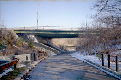
The hiking/biking trail crosses over
Springfield Boulevard on another vintage bridge
(above and below).
The original bridge over Bell Boulevard has been replaced
with a new one, most likely when Bell Boulevard was
widened since the days of the Vanderbilt/Motor Parkway.
Another ancient bridge from the early days can be found
over a walkway into Alley Pond Park, just north of Union Turnpike,
near 234th Street, in the northern Queens Village.
The current hiking/biking trail ends underneath
the Grand Central Parkway/Cross Island Parkway interchange.
You can also drive on the Eastern section of the Vanderbilt/Motor
Parkway these days, from where it begins at Half Hollow Road in the Dix
Hills area, north of the Long Island Expressway. Along its route, there
are many quiet, tree-lined strips that conjure up the images of 1910
race cars speeding along past the numerous farms that used to sustain
many Long Islanders.
The western terminus of the current Motor Parkway
in Suffolk County, at Half Hollow Road, just north of the
Long Island Expressway in Dix Hills.
Parts of the original Motor Parkway can still be found
along side the present version of the road in Suffolk County.
The current Motor Parkway passes through many bucolic
residential areas in Suffolk County (above and below).
(Click on any image to enlarge it.)
The eastern terminus of the current Motor Parkway
is at Lake Ronkonkoma, just like the original.
Technically, it ends at the intersection of Rosevale Avenue;
continuing across that road will bring you to the lake.