Wednesday, September 16, 2009

Bausert European Roots (Update)


The genealogy research on my ancestors that I completed in 2007 culminated with the publication of a booklet comprised of all of my findings to that date. Research can be an ongoing journey, however, so I’ve passed along updates to members of the families involved from time to time. The following information builds upon other data that I discovered previously.

The original Bausert family (my ancestors) that emigrated to the USA in 1866 was comprised of Johannes Joseph Bausert and wife Christine Barbara (nee: Schultz); they arrived in New York with six children (one having died during the voyage). According to German emigration papers and the ship’s registry, this family had lived in Wildbad.

Wildbad is located in the southwest corner of present day Germany in the Wüertternberg (or Baden-Württemberg) state. The town sits beside the Gr. Enz River, about 50 km (31 miles) west of Stuttgart, Germany, and 40 miles northeast of Strasbourg, France–just across the Rhine River (Rhein in German) which serves as the border between the two countries at that point. Wildbad Sprollenhaus is a few miles to the south, Wildbad Calmbach is a few miles to the north, and Neuenburg another 5 miles north of that. Freudenburg, Germany, is about 110-120 miles to the northwest of Wildbad in the Saarland state. At certain times, the entire Germany/Poland region was known as Prussia or Prussen.

All Bauserts (and Bausserts, where spelled differently but verified as the same families) I’ve researched that had a town affiliation in Germany were from the towns listed above; most others that only listed a region said they were from Baden, Wüertternberg, Saarland, or Prussen.

The only other Bauserts found outside of Germany in the 1700s were in France. Those families lived in Launstroff, Waldwiesse, Flastroff, or Creutzwald; all towns within the Lorraine province, in the northeastern Mosselle River Valley area. Creutzwald is about 45 miles north of Strasbourg; Flastroff is about 20 miles further north, Waldwiesse another 10 miles, and Launstroff an additional 5 miles.


(Click on map to enlarge it.)
The French towns where Bauserts lived are lined up
on the west side of the border with Germany.


The greatest distance between Bausert families living in the region of France and Germany/Prussia during the period of 1700 to 1900 was perhaps 110 miles as the crow flies (between Wildbad, Germany and Launstroff, France). However, it was only about 5 miles from the Bauserts in Launstroff, France,
northeast across the Saar River (border) to Freudenburg, Germany, where other Bauserts lived.

(Click on map to enlarge it.)
The town of Wildbad (or Bad Wildbad) in Germany
(on right edge of map)
and Creutzwald, France (on the upper left edge)
about 120 miles apart.


The Alsace-Lorraine provinces have long been claimed–and fought over– by both Germany and France so it’s not hard to imagine all of the Bauserts within this immediate area being related. Unfortunately, it has been difficult finding the families that provide the crucial links to prove with certainty the relationships of all the French and German Bauserts.


Tuesday, August 4, 2009

Car Show at the Imperial Palace - Las Vegas


We visited Las Vegas (Nevada) and Albuquerque (New Mexico) this past June (2009). I was surprised to find an ongoing car show at the Imperial Palace Hotel/Casino, featuring lots of old/Antique/Collectible and Custom cars, of all Makes and models. There was an admission charge but some free tickets were available so, if you're planning on going, l0ok online for them. Most of the vehicles were for sale; many had their hood open so a full-image photo really didn't do it justice. Following are a sample of what was on display.
(Click on any image to enlarge it.)

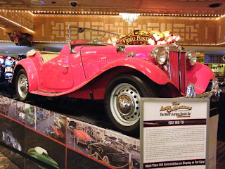
This 1951 MG TD was on display on the casino floor,
offering a taste of what was in the larger show upstairs.


1954 Nash Metropolitan.

My personal pick for "Best In Show" was this
nicely customized 1940 Pontiac Convertible
featuring a chopped top
(no easy feat on a convert).


The paint job was totally AWESOME; looked like it was an inch thick!


In case you're wondering, the tail lights are
frenched into the vertical bumper guards

(making the rear look clean but a very dangerous location for street use).


Alfa-Romeo "Bat" prototypes from the mid-1950s.


A 1933 Pierce-Arrow.


A very rare 1953 Ford two-door hardtop with half glass roof.


The origin of the term, "Woody," from Ford in 1937.

Stock 1954 Chevy two-door sedan, same colors as
the '54 four-door Ro's dad had when I met her.


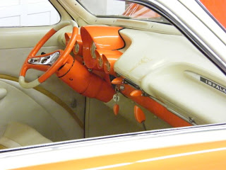
This 1949 Ford was mildly customized on the outside
but featured an Impala dashboard from the late 1950's inside
and eye-catching paint job with restrained scallops.


The listing claims it's a "350 cu. in. engine with 2 four-barrel carbs
and a Turbo 400 transmission";
I believe it's a Chevy 350 Hemi conversion .

Twin antenni are recessed into the right-rear quarter panel
and the stock tail-light lenses are neatly frenched in.

Monday, August 3, 2009

The Marty Himes Museum

Marty Himes began his career in 1955 as a stock car race driver at the now defunct Freeport Raceway on Long Island. He went on to become one of the most successful guys in the sport of racing, eventually winning 3rd place in the Formula Libre, at Lime Rock Race Course in Connecticut in 1989.

He began an unorthodox hands-on museum in 1975 containing any and everything related to auto racing as well as the toys and artifacts of his life. It’s open to anyone, for free, who gives him a call and makes an appointment; the photos from my recent visit represent only a fraction of what you can experience yourself.


(Click on any photo to enlarge it.)

Marty with a yard full of his old stock cars.

The original ticket booth from Freeport Raceway
has been transplanted to Marty's place in Bay Shore.

Dexter Park not only held stock car races
but
hosted minor-league baseball games during
the early part of the twentieth century. It closed in the 1950's.

Marty, with a home-made scooter from his youth.

Marty drives his 1938 Plymouth regularly.

You won't find gas at these prices any more.

Islip Speedway hosted stock car races
as well as 1/8 mile drag races; it closed in the 1980's.

An Irish Mail, hanging in one of Marty's garages:
popular in the 1940's, you moved the handle back & forth
with your arms to make it go and steered with your feet.
(I had one of those!)

I had one of these, too; a plastic toy ice cream truck from the 1950s.

(For more about Marty, visit http://www.thehimesmuseum.vze.com/).

Thursday, June 4, 2009

Old Richmond Hill, Revisited


On a recent Monday in May, 2009, I had to judge a camera club competition in Manhattan at 7:30 PM. Rather than drive or take the train into the city during rush hours, I decided to make a day of it and pay another visit to the New York City Archives, on Chambers Street. The main attraction for me are the thousands of old file photos of buildings within the five boroughs, taken between 1939 and 1941, for property tax purposes and available to the public. (Please check out my earlier entry on this blog for more about the NYC Archives.)

I took the Long Island Rail Road out of Hicksville, then the "A" train to Chambers Street, a few blocks from the Surrogates Court Building where the archives are located. I planned on arriving in time for lunch so I ate a sandwich I had brought along while relaxing in the park across the street from the court building.

The last time I visited the archives, I had addresses from old homes in Brooklyn that various members of my family lived in during the early 1900s; luckily, I found most of what I was looking for. This time, I was searching for buildings and businesses I remember from the Richmond Hill, Queens, area that I remember from growing up there in the late 1940s and 1950s.

I figured if I could find a 1940 photo of a place that I remember from the 1950s, chances are it would look the same. I was fairly successful, although the quality of the photos is pretty poor to begin with and I had to print out a paper negative at the archives before turning it into a positive image on my computer. I thought about going back to Queens and photographing some of the sites the way they look today, to compare how certain scenes look compared to the 1940s. But, many of the buildings I sought to find are still standing; they're just not occupied by the former shops and proprietors so I didn't think it was worth the effort.

If you grew up in Richmond Hill, or the surrounding areas like Ozone Park or Jamaica, you'll probably recognize many of the following scenes. If you were not from the area, maybe you'll still appreciate a look back at the way Queens was in the early twentieth century.

Hattie & Nettie's "general store" was built at 127-10,
95th Avenue, before 1900 and
before any other houses were built on the block!
(Click on any photo to enlarge.)

Groulings (sp?) Bakery (on the left) was at the corner of 127th Street
& 101st Avenue (formerly Jerome Avenue and,
before that, Broadway!)
There was a barber shop next door around 1940 but
it moved a couple of doors to the right (east) and
became "Tony's" when I was growing up in that area
during the 1950's.

The Casino movie theater was located just west of
114th Street on Liberty Avenue under the "el."

The Lefferts movie theater was located at
122nd Street & Liberty Avenue.

The "Triple AAA Stores" auto store, circa 1940;
I worked in that store part time
from 1959 up to the late 1960s for the owner, Sid Ableson.

I remember a Times Square store on the corner of
Woodhaven & Rockaway B'lvds
but I don't think this is it (it's not on a corner).
If anyone remembers where this was, please let me know.

I also don't remember where Becklers candy store was
so, once again, if you remember it, let me know.

A couple of months earlier, I had paid a visit to the Queensborough Public Library Archives on Merrick Boulevard, in Jamaica, Queens. There, too, I was able to browse through old photos of Richmond Hill but the quality of most of them is much better since I was able to re-photograph the actual old prints with my camera. There are also old photos available there for viewing on computers but the quality of the prints resulting from those files is not nearly as good; there are also "copyright" notices watermarked across the images.

This is the Woodhaven Junction station
(Woodhaven B'lvd & Atlantic Avenue),
around 1900, when the LIRR tracks were still above ground.

The Clarenceville station, around 1900, at
111th Street & Atlantic Avenue.
(That part of present day Richmond Hill
was originally called Clarenceville.)

The Morris Park LIRR station,
at Lefferts B'lvd & Atlantic Avenue, 1900.
(Yes, that section was originally called Morris Park.)

A rare photo of a rare LIRR station: Dunton!
The part of present day Richmond Hill,
from 126th Street to Van Wyck B'lvd
(today, the Van Wyck Expressway)
was originally called Dunton.
This was at Atlantic Avenue & Van Wyck B'lvd, circa 1922.
(Please see my earlier blog entry
for more on Dunton, Morris Park & Clarenceville.)


Sheffield's Milk Company (Atlantic Ave., from 130th Street to
about 134th Street, in 1935- shortly after it was built

Another view of Sheffield's, this time looking east, in 1936.

The Parish House for St. Benedict Joseph, Labre,
Catholic church in 1938.

The "annex" for P.S. 57, at 101-23, 124th Street, in 1938.
The main school building can be seen
on the left edge of the photo.

On this portion of a 1900 map (above)
of the Dunton/Morris Park area,
you can see the engineer's blue lines at the top
outlining where the widened Atlantic Avenue would be
(drawn in around 1930, before the work was performed)
with its familiar "S" turn by 129th & 130th Street (Maure Ave.)
I've indicated in red type the current avenues,
drawn a large square around what became
Smokey Park, and a small rectangle around the block
which housed a body shop and the Atlantic Auto Parts store
during the 1950s. Wickes was to become 127th Street;
Villa, 126th; and Cochran, 125th Street.
I've drawn a thin black oval with an arrow pointing to
the location of Hattie & Netties store
(store seen in first photo, near top of this post).

One of the blocks that comprised Smokey Park,
also built in the 1930s, is enlarged below.
There were very few homes in the area at the time
as evidenced by the lack of yellow boxes on the lots.

(Map photographed from archival book
at Queensborough Library.)

If you're enjoying my blogs, consider signing on
to "follow" them and please pass along
the web addresses to others
who might appreciate them.
Questions, comments and corrections
are always welcome.